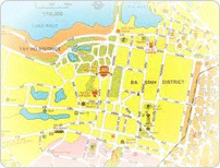
Creation of a Geographical Information System with information of public transport of greater Hanoi
This map is based on Quickbird satellite photos, an action financed by Ile de France. It is an electronic cartography containing GIS coordinates.
This tool is used for the purposes of urban and regional planning, including the transport model line to Bac Ninh, to estimate the size and population of people, living in rural and semi rural villages and townships around Hanoi. It also permits to complement the information system of Hanoi Public Transport, the maps to be posted on bus stops and maps with bus routes available for sale.
A simplified version of this map is consultable on internet via Tramoc website
The GIS is a useful tool to help planers of the study center plan bus line or bus stop modification