2 kinds of maps for the passengers have been created by the study center:
·Schematic maps of the network.
It is the first pocket map in Hanoi, in an A3 format (10 x 7cm when folded). It is been designed according to RATP standards. First printing of 10 000 copies have been distributed for free to passengers.
·Schematic bus line maps in the buses
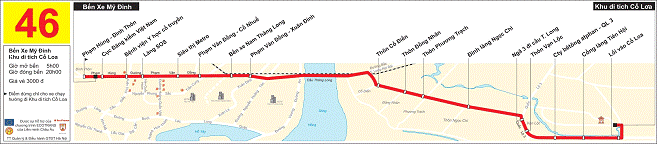
They have been designed based and with the help of RATP experts. The goal is to help passengers find where they are and where is their bus stop at any moment when they are in the bus. They include:
-bus stop name (inexistent before) : defined according to precise criteria’s, they should help passengers to find quickly the location of the bus stop in the city.
-The environment of the line: major points (parks, universities) located near the line and streets crossing the root of the line.
Map installed in the buses of line 46
INTRODUCING SMARTCARDS
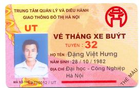
The goal is to reduce fraud, improve boarding time and a better knowledge of the network ridership. A pilot line is to be equipped with validators adapted to smartcard and monthly ticket on this line will be replaced by smartcard.